


GTMC2_J1

PhilippeC54
User
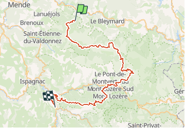

Length
66 km

Max alt
1560 m

Uphill gradient
1210 m
Km-Effort
84 km

Min alt
537 m

Downhill gradient
1834 m
Boucle
No
Creation date :
2016-06-14 00:00:00.0
Updated on :
2016-06-14 00:00:00.0
5h15
Difficulty : Difficult

FREE GPS app for hiking
 SityTrail
IGN / Geographical institutes
SityTrail Plus
The world is yours!
About
Trail Mountain bike of 66 km to be discovered at Occitania, Lozère, Mont Lozère et Goulet. This trail is proposed by PhilippeC54.
Description
Auriac
Florac
Positioning
Country:
France
Region :
Occitania
Department/Province :
Lozère
Municipality :
Mont Lozère et Goulet
Location:
Saint-Julien-du-Tournel
Start:(Dec)
Start:(UTM)
551661 ; 4926232 (31T) N.
Comments